List of counties in Hawaii
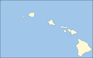
The five counties of Hawaii on the Hawaiian Islands enjoy somewhat greater status than many counties on the United States mainland. Counties in Hawaii are the only legally constituted government bodies below that of the state. No formal level of government (such as city governments) exists below that of the county in Hawaii. Because education is carried out by the Hawaii State Department of Education (and not a function controlled by local school boards like the other 49 states),[1] property taxes and user fees collected by the counties support mostly road maintenance, community activities, parks (including life guards at beach parks), garbage collection, police (the state police force, called the Hawaii Department of Public Safety, is limited in scope), ambulance, and fire suppression services.[2] All the counties were created in 1905 from unorganized territory, seven years after the Territory of Hawaii was created.[2][3] The county of Kalawao is used exclusively as a leper colony, and does not have many of the elected officials the other counties do.[4]
County information
The Federal Information Processing Standard (FIPS) code, which is used by the United States government to uniquely identify counties, is provided with each entry. The FIPS code for each county links to census data for that county.
| County |
FIPS code [5] |
County seat [6] |
Etymology |
Population [7] |
Area [7] |
Map |
|---|---|---|---|---|---|---|
| Hawaii County | 001 | Hilo | Island of Hawai'i, with which the county is coterminous | 148,677 | 5,087 sq mi (13,175 km2) |
 |
| City and County of Honolulu | 003 | Honolulu | "Sheltered bay" or "place of shelter" in Hawaiian language[8] | 876,156 | 2,127 sq mi (5,509 km2) |
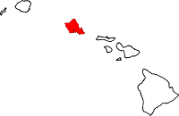 |
| Kalawao County | 005 | None (administered by Hawaii Dept. of Health)[4] | The village of Kalawao, which lies within its boundaries. The smallest county in the U.S.[9] | 147 | 52 sq mi (135 km2) |
 |
| Kauai County | 007 | L─½hu'e | Kauai Island, the largest of the islands in the county. | 58,463 | 1,266 sq mi (3,279 km2) |
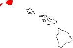 |
| Maui County | 009 | Wailuku | Maui Island, the largest of the islands in the county. | 128,094 | 2,399 sq mi (6,213 km2) |
 |
References
- Ôåæ Hawaii State Department of Education. "Hawai'i DOE, About". http://doe.k12.hi.us/about/index.htm. Retrieved 2007-04-26.
- Ôåæ 2.0 2.1 "Hawaii State: Facts & Figures - Des Osman Realty". http://osman1.com/hi-facts.html. Retrieved 2007-04-26.
- Ôåæ Office of the County Clerk. "Foreword" (PDF). 2000 County Charter of the County of Hawaii. http://www.hawaii-county.com/council/charter2000/item%201-Foreword.pdf. Retrieved 2007-04-26.
- Ôåæ 4.0 4.1 "Hawaii's 4 (or 5) Counties". 1999-09-01. http://www.chem.hawaii.edu/uham/counties.html. Retrieved 2007-07-23.
- Ôåæ "EPA County FIPS Code Listing". EPA. http://www.epa.gov/enviro/html/codes/hi.html. Retrieved 2007-04-09.
- Ôåæ National Association of Counties. "NACo - Find a county". http://www.naco.org/Template.cfm?Section=Find_a_County&Template=/cffiles/counties/state.cfm&state.cfm&statecode=HI. Retrieved 2007-04-26.
- Ôåæ 7.0 7.1 "Hawaii QuickFacts from the US Census Bureau". State & County QuickFacts. http://quickfacts.census.gov/qfd/maps/hawaii_map.html. Retrieved 2007-04-18.
- Ôåæ "Honolulu Homes Guide". 2005. http://www.honoluluhomesguide.com/. Retrieved 2007-07-23.
- Ôåæ "Kalawao (Hawaii, United States)". Encyclop├ªdia Britannica Online. 2007. http://www.britannica.com/eb/topic-310076/Kalawao. Retrieved 2007-07-23.
|
||||||||||||||||||||
|
|||||